US Route 60States traversed: Arizona, New Mexico, Texas, Oklahoma, Missouri, (Illinois,) Kentucky,
West Virginia, and Virginia |
|
US Route 60 runs east-west from Virginia Beach, Virginia, to northern Oklahoma, but it continues west into northernmost Texas where it turns into a diagonal southwesterly route, to end in western Arizona. The easternmost stretch of US Route 60 follows General Booth Boulevard in Virginia Beach, with the final endpoint occurring at the junction with Rudee Point Road. US Route 60 then gets started, passing the eastern endpoint of US Route 58, through the rest of the Hampton Roads area and beyond. US Route 60 continues west across Virginia, West Virginia, and Kentucky, alternating back and forth from following the Interstate 64 corridor until Louisville, Kentucky. Starting at Louisville, US Route 60 follows the southern bank of the Ohio River through the rest of Kentucky. US Route 60 crosses the mouth of the Ohio River into Illinois, then immediately crosses the Mississippi River westward into Missouri. US Route 60 runs across southern Missouri and northern Oklahoma before turning southwesterly through Amarillo across Texas's northern panhandle. US Route 60 proceeds eastward across central New Mexico and central Arizona, to end at Interstate 10 just shy of reaching Quartzsite in western Arizona.
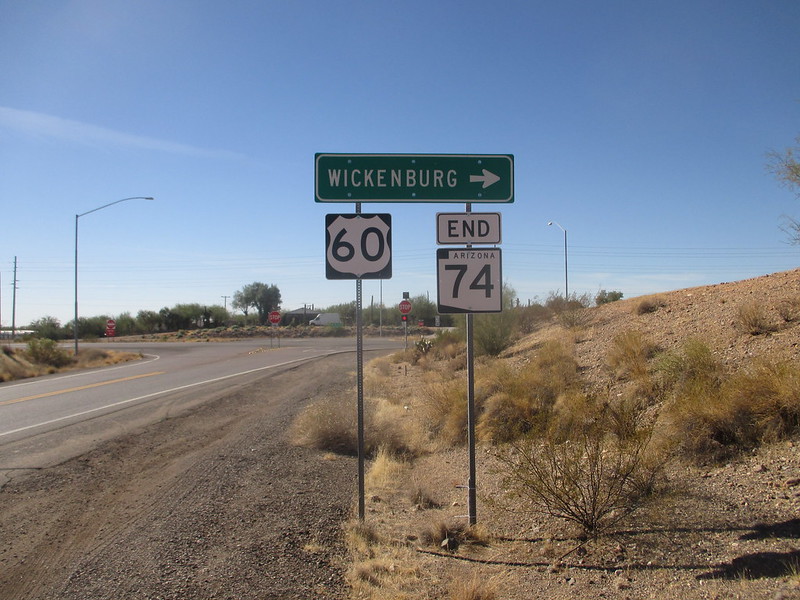
My photo for US Route 60 comes from a trip to Arizona that took place in November 2017. This assembly faces east at the western end of Arizona Route 74, just southeast of Wickenburg in central Arizona (home to the southern end of US Route 93). There should be a two-ended arrow placard below the US Route 60 shield, but it's missing from the sign assembly shown. I originally planned to photograph US Route 60 somewhere farther east, but the Arizona desert usually has very little obstructing the main outdoor light source for photography (the Sun).
Back to the nationwide main page.
Back to the home page.
Back to the nationwide main page.
Back to the home page.
